The largest of them:
- Sevastopol (Big or Ahtiarian), crashed into the peninsula at 8 km from west to east. The area of her mirror is & ndash; 5.8 km2;
- South, branching from it to the south by 1.8 km. Its water area is 0.4 km2,
These bays divide the city into 3 parts, or, as Sevastopol say, "side": North, Ship and South (it's Central, or Urban). It is believed that the Sevastopol Bay occupies the third place in the world for convenience, after Hong Kong and Sydney.
Other large bays of Sevastopol (from east to west:):
- Streletskaya,
- Round (Omega);
- Double (formed from the bays of Kamyshov and Kazachy),
- Balaklava.
From the territory of the Sevastopol region, all 3 ridges of the Crimean Mountains begin - the Outer, Internal and Main.
The outer ridge begins at Cape Fiolent and extends along the border of the Crimean steppes, passes north of Simferopol, and merges in the east with the Inner Ridge. The length of the outer ridge is 114 km with an average altitude of about 300 m.
The inner ridge stretches from Mekenzievy mountains to the town of Agarmys near the Old Crimea for 125 km. The height of this ridge ranges from 400 to 500 m.
The main ridge begins with the Balaklava heights. Further to the south it steeply cliffs to the side of the sea, forming Cape Aya. From here the ridge, circling the Baidar basin from the south, extends to the south-east to Alushta, there it turns to the east and reaches Cape Ilya near Feodosia.
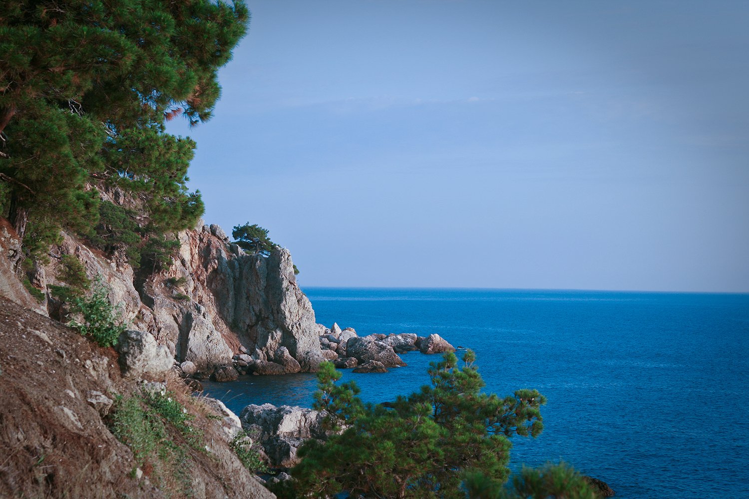
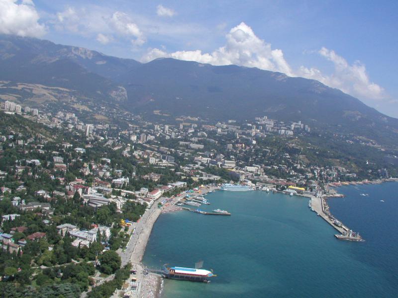
Southern coast of Crimea is & ndash; A narrow strip of land, separated from the north by the main ridge of the Crimean mountains, and from the south washed by the Black Sea. Opposite the Baydar Gate, its width reaches 2 km, in the Yalta - 6 km, the maximum - at the Alushta Amphitheater - 12 km. The southern coast begins at Cape Aya in Sevastopol and ends at the foot of the extinct volcano Karadag (near Feodosia).
Ridges alternate between intermontane depressions, consisting of flat basins, which were formed by weathering and erosion by surface waters of supple rocks.
The foothills of the foothills (Outer and Inner) are shaped like cuestas, where the northern slopes are shallow and long, and the opposite slopes are steep and short.
A feature of the Main Ridge is that its tops do not have the kind of a pointed ridge, but are plains, here and there flat, here and there & ndash; hilly. Such tabletop surfaces are called yail. Within the boundaries of the Sevastopol region, gradually rising from the south-west to the northeast, the Western Yail: Baidarskaya (height 500-700 m) and most of the Ai-Petrinskaya (1200-1300 m) stretch unequally in width and shape. The southern slope of the Ai-Petrinskaya yaila in its middle part abruptly cuts to the sea, forming the so-called Baidaro-Castropol wall (850-950 m), at the foot of which the Yalta road passes.
Geologically, the mountainous Crimea belongs to the young mobile folded zone formed in the Cenozoic (Alpine geosynclinal region).
Mountain-forming processes in the Crimean mountains continue even now, as evidenced by periodic earthquakes in the mountainous Crimea. The Sevastopol region is included in the seismically active zone. There have been, are and will be earthquakes, the most famous of which are two destructive earthquakes 1927. Observations at the seismological station & quot; Sevastopol & quot; (Chernoreche village) indicate that small earthquakes occur constantly. Most of Sevastopol is located in the 7-point zone, and Balaklava and the entire southern coast - in 8-point (on a 12-point scale).
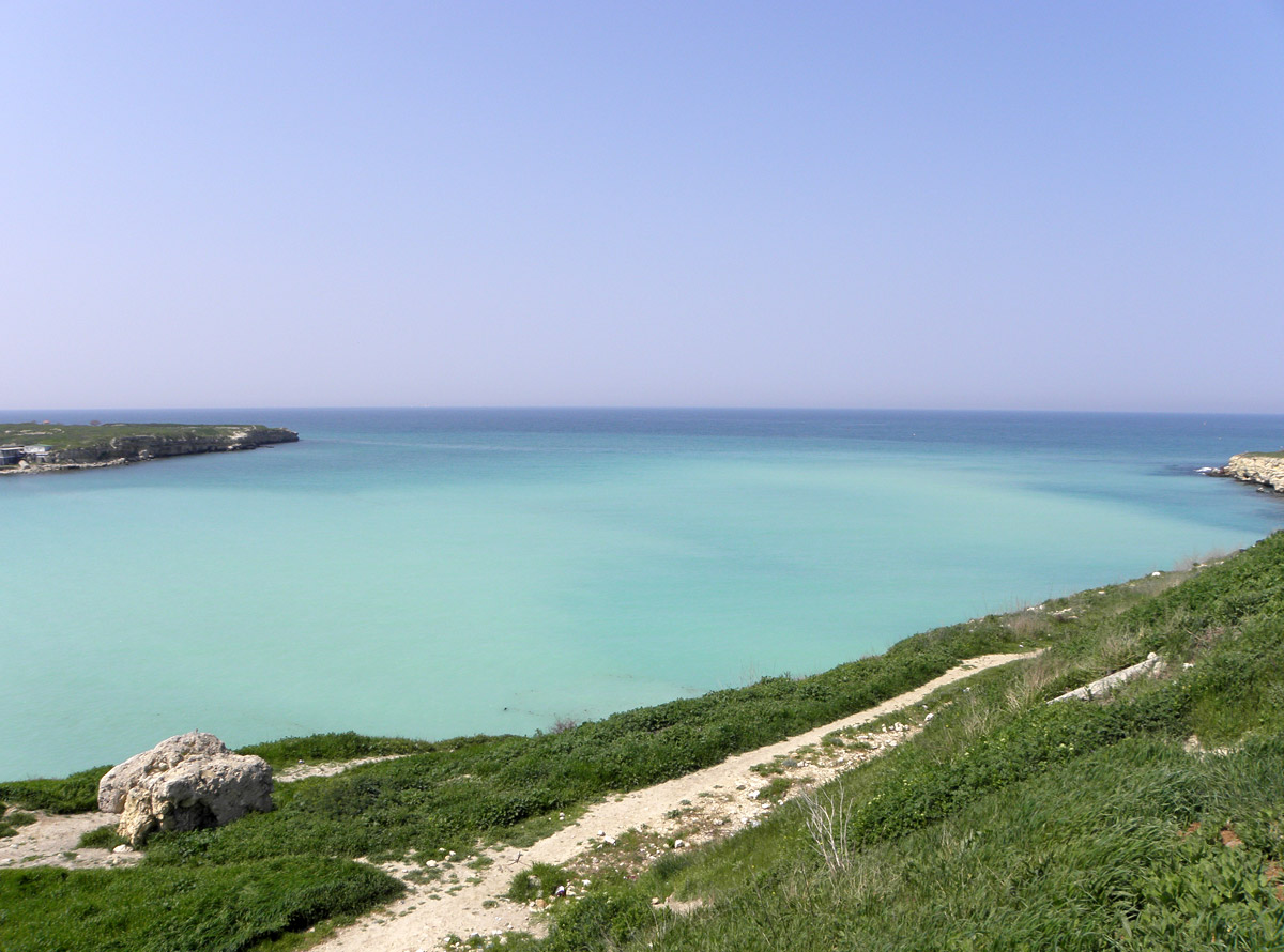
One of the unique corners next to Sevastopol - Fiolent - cape, located on the Heraklion peninsula, between St. George's monastery, the Gulf of Diana and the cape of the Sphinx. Its ancient name Parthenium (maiden, virgin) is associated with the ancient Greek myth of Iphigenia.
In translation from the Turkish Fiolent (Felenk - Burun) - Tiger Cape, t. on the precipice of the cape there are alternating bands of yellowish limestone and dark trachyte, reminiscent of the coloring of a tiger skin. In the last century, every traveler visiting the Crimea considered it his duty to visit the holy monastery - the St. George Monastery, founded back in 891. Here there were Pushkin and Aivazovsky, Alexander I and Nicholas II, Prince Golitsyn and many others. An ancient monastery, a spectacular 800-step descent to the Jasper beach along the ancient monastic ladder, legends and legends of this region will be remembered for a long time.
The Fiolent Coast, framed by virgin, almost a hundred meter high cliff-shaped rocks, & ndash; this is the most beautiful beaches with a small, unusually picturesque, amazingly colorful sea pebble, which includes a lot of pebbles of semiprecious breeds: jasper, sapphirine, agate, carnelian, red & ndash; brown serder and even malachite.
Wild trees growing on rocks, and planted by monks of St. George Monastery trees, allow you to take complex aromatherapy every day on the beach at Fiolent. Essential oils with bactericidal properties, juniper, pistachio, jasmine and rock oak, cornel and figs, combined with sea and mountain air form a flavor cocktail that has a beneficial effect on the physical and emotional state of a person.
Silence, tranquility and pacification of the unique Jasper beach are not disturbed by personal noisy water activities. The picturesque nature, the stone lace of the rocks, the vast expanse of the blue sky and the emerald sea beckon with its serenity.
Diving lovers can enjoy the delights and charm of the sandy bottom with fantastic underwater rocks covered with seaweed, mysterious caves and caves, a variety of marine life.
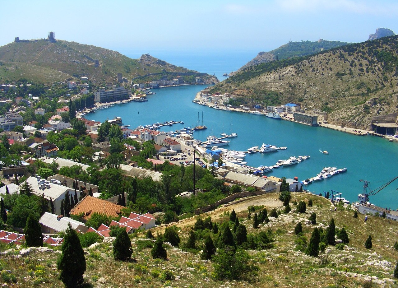
Another decoration of the city & ndash; Balaklava bay, located between the high rocky mountains. This is a unique creation of nature. A narrow, winding strait is connected to the sea in 1.5 km, and as the rocky coast makes several turns when entering the bay, then the harbor is not noticeable at all from the open sea.
The Balaklava Bay is deep (up to 17 meters, at the entrance - 38 meters, its width is from 128 to 425 meters) and surprisingly calm. Water splashes just 30 centimeters from the level of the waterfront and, surprisingly, never floods it.
To see Balaklava Bay completely, it's best to climb the Rock (Fortress Hill), from where, from the eastern shore of the bay, the city and its surroundings are visible as in the palm of your hand. A wonderful view opens from the Serpentine Mountains to the vast sea and the coast with a bizarre pile of rocky mountains! Dizzy! In any weather here it smells like sea: fish, iodine and algae.
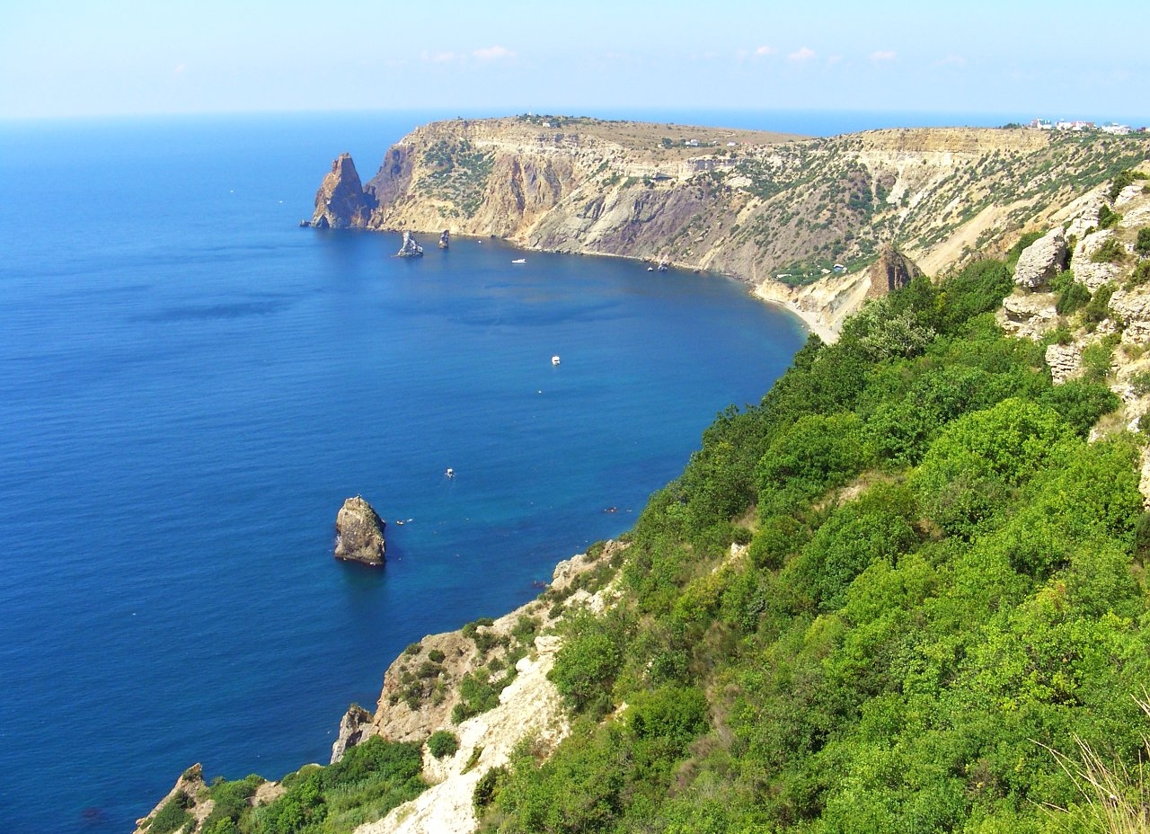
In the distance, in the southeast, Cape Aya is seen, behind which the Southern Coast of Crimea begins.
Cape Aya is a 13-kilometer coast protrusion. The name of the cape is derived from the Greek word "agios" & raquo; (holy).
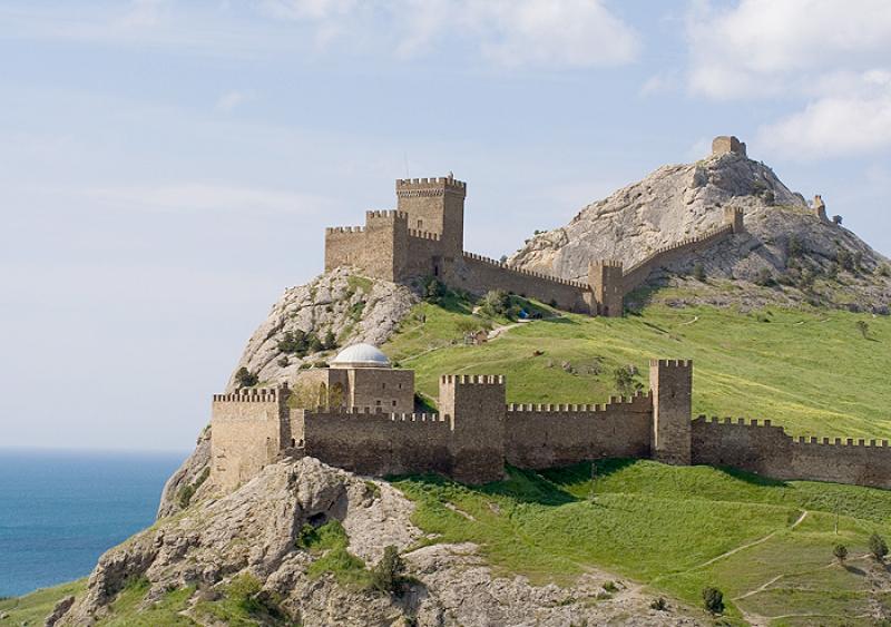
The cape is a steep spur of the Main ridge of the Crimean mountains, it continues to the base of the Kush-Kaya mountain. The highest peak on Cape Aya — Kokiya-Kiya rock (& laquo; blue rock & raquo;) with a height of 558.5 meters. The rocks that make up Cape Aya are composed of Upper Jurassic marble-shaped limestones. Mountain slopes are covered with relict mediterranean light forests. At the bottom of the promontory there are grottos. Above Cape Aya towers the Cokia-kaya rock with the remnants of the Kokiya-Isar castle (X-XIII centuries). The fortification includes a defensive wall, a chapel, gate tower and other buildings. From the south and west this place is protected by steep cliffs and the sea, from the northeast - by the difficultly traversed Kokiya-bel ridge.
Mount Spilia (Cave), or ascetic, is associated with the legend of the hermit ascetic living on it near Cape Aya.
Between Spilia and the Fortress Mountain, on which are the remains of the Genoese fortress Cembalo, abruptly breaks off to the sea of Shaitan-dere (Devil's Gully). Its unique beauty amazes everyone who ventured to descend at least once to its tiny sandy beach.
Micro-Yalo (Small Shore), called the locals "Silver", is located to the east of Shaitan-Dere. The beach, to which along the steep shore of the sea is a picturesque trail. Behind him stretched Megalo-Yalo (Big Shore) & ndash; & laquo; Golden & raquo; beach.
Between & laquo; Golden & raquo; beach and Cape Aya there is a picturesque tract of Ayazma (Ayazma). In 1927, archaeologists here discovered the remains of a settlement of the 10th-10th centuries. When viewing this area you can see fragments of the preserved round structure, residential buildings, the foundation of a small temple.
Part of Ayazma with its cozy coves and comfortable beaches carries the popular name of Fig. One of the rocks here has the shape of the fruit of this beautiful and very useful southern plant.
In the coastal waters of Sevastopol and in its bays there is a great species diversity of fish: mullet (the most common species is the Sinhil, the largest species is the loban, and also the sharon), the sultanque (barabule), which appears near the coast of Sevastopol in May-June and October, the Black Sea horse mackerel is a permanent inhabitant of the region's coastal waters, the sea urchin & ndash; scorpion, which settles among the coastal rocks, smaridae (sea bass), greenfinch (zelenukha or rulena), numerous bulls (5 species), roundwood, martovik, whip, bayonet, rotan and, in addition, sea dogs and sargan-needle settle in the rocks and rocks of the coves.